| By Alex MacLean, The Union Democrat December 03, 2015 01:00 am
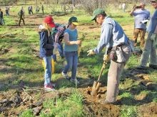
Tuolumne County elementary school students in March helped plant seedlings in the Groveland Ranger District (above). Courtesy photo / Stanislaus National Forest Service. More than two years since the 2013 Rim Fire, the Stanislaus National Forest is seeking input on a proposed plan to replant trees across 21,300 acres that burned in the historic blaze. Timber industry and environmental leaders in Tuolumne County who disagree over some aspects of the plan are hoping to work together in the coming months on a compromise that would keep the project moving forward. “I think you’ll find agreement from everybody here that something needs to be done out there and needs to be done quickly,” said logger Mike Albrecht, who owns Sierra Resource Management in Jamestown and stays active in issues affecting the local timber industry. The Rim Fire consumed more than 257,000 acres in the Central Sierra region from August to October 2013, including about 154,000 acres in the Stanislaus National Forest. Some areas burned so severely that little to nothing survived plantwise. Much of the service’s proposed reforestation plan calls for replanting in the high-severity burn areas where natural regrowth would be unlikely due to the lack of standing trees. “A lot of the (Rim Fire area) wasn’t forested to begin with, including the canyons,” said Maria Benech, who is leading the service’s reforestation project. “The areas we’re really focusing on are the high-intensity burn areas where most or all of the trees were killed, and natural regeneration is improbable because there’s no seed source.” The recently unveiled plan is a scaled-down version of an earlier proposal to replant about 30,000 acres. Benech said the scope was reduced because about 4,000 acres previously targeted will be managed for deer habitat, while another 4,000 may grow back naturally. All planting is scheduled to occur over a period of roughly six to seven years, Benech said. Professional crews that can plant about 1,000 to 1,200 trees per day would be contracted to do the work, while about 200 acres would be planted by volunteers. “We’ll be doing all of this by hand,” Benech said. “The ground out there isn’t really conducive to machine planting.” Roughly 7 million saplings would be needed to replant the whole area, Benech estimated. Most would likely come from the service’s nursery in Placerville from locally gathered seed. Much of the area would be reforested with ponderosa pine, though incense cedar, sugar pine, douglas fir, white fir and giant sequoia may also be used. The plan calls for using the herbicide glyphosate to kill brush that could otherwise prevent the conifer saplings from maturing. Benech said one alternative outlined in the plan would use no herbicide, but it would likely be costly because the brush would need to be removed by hand or machine. Completely foregoing the use of herbicides would also reduce the survival rate of saplings from 75 to 50 percent, she added. John Buckley, of the Central Sierra Environmental Resource Center in Twain Harte, took issue with the amount of herbicide proposed, saying it could prove controversial. Glyphosate, the most widely used herbicide in the world, was recently linked to cancer by the World Health Organization. “By reducing the level of controversy, our center believes we can get the reforestation going without the chance of lawsuits from outside forces,” he said. “Look for areas that are least controversial for planting and use herbicides when needed, but minimize the overall amount.” Buckley also criticized the plan’s call for replanting more than 400 trees per acre in some areas, arguing that 100 to 150 trees per acre would create a healthier and more fire-resilient forest. Albrecht, on the other hand, supports the use of herbicides and feels a “fair number” of trees should be replanted to ensure that the forest regrows. Despite the disagreements on the approach, there’s hope for both sides to reach some sort of compromise that would prevent the project from getting derailed. “Our center is supportive of getting the reforestation going,” Buckley said. “We think there’s a middle ground that people with many different points of view can agree is balanced.” Albrecht and Buckley serve as co-chairmen of Yosemite Stanislaus Solutions, a collaborative group of timber industry and environmental leaders. The group previously worked with Forest Service officials to craft a logging project across more than 30,000 acres in the Rim Fire area that successfully withstood lawsuits aimed at stopping it from outside environmental organizations. Both say they agree that the post-fire logging and proposed reforestation are necessary to help restore the forest for wildlife habitat, recreation and economic opportunities. “Choosing a no-action alternative would lead to tens of thousands of acres of brush fields and dead trees just falling over and piling on top of each other,” Albrecht said. “It would not only create a tremendous fire hazard, but change the look of the forest for many generation |
YSS in the Press and Stories of Interest
Forest staff trims acreage in Rim fire replanting plan
Conifer seedlings would go on less acreage than earlier proposed
Most of massive 2013 burn is not part of plan
Environmentalists raise concerns about herbicide use
BY JOHN HOLLAND jholland@modbee.com
The Stanislaus National Forest has reduced by nearly a third, to 21,300 acres, the land it proposes to replant in the Rim fire area.
A timber industry leader said he was disappointed by the new plan but hopes to work with other interested parties to get the project moving. An environmental leader objected to using herbicides to help the conifer seedlings survive, but he too said he hopes for compromise.
The forest staff had proposed in February to replant 30,065 acres but reduced it following a closer look at conditions left by the massive 2013 fire.
Both proposals are a small percentage of the 257,314 acres in the burn area. Some of it is private timberland where reforestation already is underway. Some is in Yosemite National Park, where burned land is left to recover naturally. And the national forest portion includes areas that lack roads, that are brush rather than timber, or that burned lightly enough that surviving trees will drop cones that produce new seedlings.
The revision shifts 4,031 acres from replanting to natural regeneration and adds about 3,400 acres that would be managed more for oaks, which is good habitat for deer but not a source of lumber.
Recovery from the fire, the largest ever recorded in the Sierra Nevada, is key to a Tuolumne County timber industry that employs several hundred people. It also matters to the northern San Joaquin Valley, which gets much of its water from this area and is the source of many recreational visitors.
The new reforestation plan will undergo 45 days of public comment, including an open house Thursday in Sonora. Forest Supervisor Jeanne Higgins could make a tentative decision in April and a final one by August, reforestation team leader Maria Benech said. Planting could start in 2017 and take three to five years to complete.
The fire started Aug. 17, 2013, near the confluence of the Tuolumne and Clavey rivers. Keith Matthew Emerald of Columbia was accused of building an illegal campfire that caused the blaze, but federal prosecutors in May dropped the charges because two key witnesses had died.
GETTING THIS AREA REPLANTED AS QUICKLY AS POSSIBLE IS A VERY HIGH PRIORITY FOR FORESTERS AND NATURAL RESOURCE MANAGERS.
Mike Albrecht, industry forester
Industry forester Mike Albrecht said he has not read details of the new reforestation plan but would like to see the U.S. Forest Service “plant as many acres as it possibly can.” He owns a Jamestown-area company that does logging and other work in the woods, and is a leader with the Tuolumne County Alliance for Resources and Environment.
“Getting this area replanted as quickly as possible is a very high priority for foresters and natural resource managers,” Albrecht said. He added that herbicides are needed for plantation survival and he hopes that litigation does not delay their use.
Albrecht also co-chairs Yosemite Stanislaus Solutions, a coalition of business, environmental and other groups concerned about the national forest and park. The other co-chairman is John Buckley, executive director of the Central Sierra Environmental Resource Center in Twain Harte.
Buckley said his and other environmental groups “strongly support replanting vast areas of the Rim fire that burned so severely few or no conifers survived.”
But he said the current proposal relies too much on the herbicide glyphosate.
“The agency should only be proposing to spray a potential cancer-causing chemical on the relatively small percentage of acres where tree seedlings truly won’t survive without herbicides,” Buckley said.
CSERC also said the plantations should have lower tree density and more irregular spacing than in the Forest Service proposal, so they would better mimic fire resistance of natural forests.
John Holland: 209-578-2385
Jerry Brown declares emergency for dying trees
BY DAVID SIDERS
October 30, 2015-The Sacramento Bee
Lamenting “the worst epidemic of tree mortality” in the state’s modern history, Gov. Jerry Brown on Friday sought federal aid to remove dead trees from California forests and called for more controlled burns to reduce the risk of wildfire.
The declaration, including a controversial exemption from environmental reviews, comes amid California’s ongoing drought and a bark beetle infestation that has killed millions of trees weakened by lack of water.
Brown said the die-off exacerbates the risk of wildfires and the threat of erosion. He ordered state agencies to remove dead or dying trees from high-hazard areas and said his administration will work with federal authorities to expand controlled burns.
Brown is also seeking to increase the number of days tree waste can be burned, while ordering the California Public Utilities Commission to expedite contracts for bioenergy facilities that use forest products from high-hazard zones.
The order includes an exemption from the California Environmental Quality Act for efforts to remove dead or dying trees, alarming some environmentalists.
“CEQA requires agencies to tell the public what they’re doing, and to try to lessen the environmental damage of their projects,” said Kevin Bundy, a senior attorney at the Center for Biological Diversity.
Bundy said Brown should be using his executive authority in a “more restrained fashion than this seems to represent.”
In a letter to U.S. Agriculture Secretary Tom Vilsack requesting assistance, Brown said California “is facing the worst epidemic of tree mortality in modern history.”
“Tree mortality across California’s forests is putting lives and critical infrastructure at risk,” he wrote, “greatly increasing already dangerous wildfire conditions and exacerbating threats posed by falling trees.”
Read more here: http://www.sacbee.com/news/politics-government/capitol-alert/article41962989.html#storylink=cpy
X-ray technology reveals California’s forests are in for a radical transformation
Thomas CurwenContact Reporter LA Times, October 20, 2015
Full Article with Illustrations
Biologist Greg Asner first heard the numbers in April, but they did little to prepare him for what he saw.
The Forest Service had estimated that nearly 12.5 million trees in the state’s southern and central forests were dead. But as Asner peered down upon the same forests from his airplane at 6,000 feet, he saw something far worse.
California’s drought-parched landscape was poised for a radical transformation. Much of the low-elevation forests near Mt. Pinos in the Los Padres National Forest and in Pinnacles National Park were going to disappear if trends continued.
A scientist with the Carnegie Institution for Science, Asner has a practiced eye for forest health, and with instruments aboard his plane that give him X-ray eyes into the foliage, he is able to assess not just dead trees but trees so stressed by the drought that their death is likely.
For three weeks this summer, he and his team flew out of Sacramento and Bakersfield, recording the devastation. Even if the drought were to end in a historic El Niño this winter, Asner worries that the most stressed trees will continue to fail.
The U.S. Forest Service shot this video of the Stanislaus National Forest in the central Sierra Nevada in July. Flying at about 1,000 feet, covering about five acres per second, Forest Service observers count dead trees — conspicuous for the brown foliage — and extrapolate over plots that are the approximate size of a football field.
There is no saying which trees will die, but by his estimation the count statewide could be close to 120 million — as much as 20% of the state’s forests.
Tarnished beauty
On a hot summer morning, Asner boards his Dornier 228, a twin turboprop, at McClellan Airfield on what he hopes will be the final day of his survey. He needs to fly along the coast toward the Oregon border, but conditions are deteriorating.
An armada of firefighting aircraft has taken off at dawn to fight an outbreak of new wildfires to the north. The air is hazy with smoke.
Above the city of Santa Rosa, the plane veers northwest over the forests west of Guerneville toward the Lost Coast.
Asner, 47, sits in the cabin with Robin Martin, who manages the instruments and relays navigation instructions to the cockpit. They work in front of two monitors. She’s a lefty and he’s a righty, so they share a mouse pad. It helps that they are married.
To understand how Asner’s instruments work, you have to first step inside a leaf. There amid the busy factory of photosynthesis, water molecules are bending, stretching, rotating and vibrating.
Greg Asner’s vivid topographic images of Crescent Meadow in Kings Canyon-Sequoia National Park are created from data collected by an onboard spectrometer and laser. Healthy trees are blue, and drought-stressed trees run from mild (yellow) to severe (red).
These motions resonate into the atmosphere as reflected light, which is picked up by an on-board spectrometer that divides it into 480 bands from ultraviolet to shortwave.
Much like star light reveals a star’s distant chemistry, these bands are analyzed for their chemical content. Water is the primary focus: The more water in the leaves, the less reflected light, and the more reflected light, the drier the foliage.
The spectrometer works in conjunction with a laser that fans out beneath the aircraft, creating a 3-D image of the forest below.
By marrying the data from the spectrometer and the laser, Asner creates topographic images that show the condition of the forest. Healthy trees are blue, and drought-stressed trees run from mild (yellow) to severe (red).
The images help him to correlate terrain and tree stress. Higher tree stress, for example, often occurs on steep slopes and near meadows.
For Asner’s mostly Canadian crew, the Golden State is a tarnished beauty.
“It’s just burnt,” says pilot Don Koopmans of Saskatchewan.
Asner’s assessment is equally blunt.
The mountains ringing Los Angeles are “a tinderbox.”
The oak forests in the Sierra foothills are “in big trouble.”
Pinnacles is “not a happy place for a tree,” and the forests northwest of Redding are surprisingly compromised.
To explain what 120 million trees dying across the state might mean, Asner paints a picture of California’s ecological diversity and size. He then takes out his calculator.
He estimates there are 585 million to 1.6 billion trees in the state’s forests and apologizes for not being more precise. An accurate census, he says, has never been conducted, but 120 million represents 7% to 20%. Under normal circumstances, forests lose between 1% and 1.5% of their trees annually.
“At what point will the forest change into something else? We don’t know,” Asner says. “We don’t know when the lack of rain will lead to runaway conditions where the forests are beyond repair.”
Such a transition, especially in the lower elevations, is already underway in parts of the West, where nearly 6 billion trees — 13% of the area of western forests — died from 1997 to 2010 because of drought and the bark beetle.
Yet as grave as the effects of the drought have been, Asner insists there is hope.
“If I looked around and thought there was no way to deal with these problems, I would be pessimistic,” he says. “But there is a way with effective management.”
Among other things, aerial images can help land managers identify vulnerable terrain and consider how to strengthen stressed trees and protect healthy ones.
A march uphill
The study of forests is a formative science, and conclusions — like a definitive number for the trees that will die — are hard to come by.
Park Williams, a bioclimatologist at the Lamont-Doherty Earth Observatory at Columbia University who has been studying the California drought, is not surprised by Asner’s numbers.
If only half succumb, it would register as a very big event, Williams said.
“Think of it as one gigantic ax swing at the forest,” he said. “It takes a huge chunk out of the population, and if we see two or three more of these droughts, then that’s even more ax swings.”
Jeffrey Hicke, an associate professor in the department of geography at the University of Idaho, said that regardless of current tree mortality rates, the state will not lose its forests entirely. But he adds, based on the observations, the low-elevation forests are in greatest jeopardy.
Beyond this year’s drought, as climate change brings warming, tree species will migrate, Hicke said. Older trees will die, and younger trees will take root.
The Numbers Crunch: New normal for wildfires requires new approaches
by Foon Rhee The Sacramento Bee October 2, 2015
We’ve all seen how bad this year’s wildfire season has been in California. Now we have confirmation of how historically horrible it has been – along with a warning that we better get used to it.
The Public Policy Institute of California updated Cal Fire records to account for the late-summer Rough, Valley and Butte fires.
The Rough fire in Fresno County makes the all-time top 20 list for acres burned, while the Valley fire in Lake County and Butte fire in Amador and Calaveras counties make the top 10 for most destructive.
Finally on Thursday, the Butte fire, which started Sept. 9, was completely extinguished, but not before burning nearly 71,000 acres, killing two people, injuring one and destroying more than 800 structures.
As of Thursday night, Cal Fire reported that the Valley blaze, which began Sept. 12, was 97 percent contained at about 76,000 acres. It killed four civilians, injured four firefighters and destroyed nearly 2,000 structures.
Fire season isn’t over yet. Now the highest risk moves to Southern California, which usually has its biggest wildfires in the fall when Santa Ana winds pick up. Many on the all-time lists burned in Los Angeles, San Diego or Ventura counties.
PPIC says it’s no coincidence that two of the three largest fires on record – the Rush fire in 2012 in Lassen County and the Rim fire in Tuolumne in 2013 – have occurred since the drought started in 2012.
Hotter temperatures and dry conditions reduce moisture in live and dead trees and vegetation – a recipe for more frequent and intense fires. Once they do start, higher temperatures and lower humidity mean they’re more likely to grow during the night, giving firefighters less chance to catch up.
Even if it does rain, it’s not necessarily a good thing. Storms last December fed new growth of wild grass, but because the drought took hold again in January, the vegetation had dried up by March, creating more fuel for fires.
CalFire says that through Sept. 26 it has responded to 5,500 wildfires this year that consumed more than 305,000 acres. That compares to a five-year average of 3,850 fires and 107,000 acres.
The worsening fire seasons have sparked deeper debates about how best to prevent wildfires in the era of drought and climate change. Some researchers say the Forest Service should allow smaller fires to burn out more often, consuming dry brush and other fuel, to prevent bigger ones. PPIC also blames poor forest management practices for bigger fires.
There’s also more interest in how best to pay for fighting them if this is the way it’s going to be. Advocates say big wildfires should be treated as other natural disasters, using emergency money and not starving regular accounts that could otherwise be used for wildfire prevention.
These debates are a healthy development for smart policy and will eventually lead to healthier forests. It’s too bad that it’s too late for the families and communities that have already lost so much.
BY THE NUMBERS
California’s most destructive wildfires:
- Tunnel-Oakland Hills (Alameda County, 1991): 25 deaths, 2,900 structures destroyed
- Cedar (San Diego County, 2003): 15 deaths, 2,820 structures
- Valley (Lake, Napa, Sonoma counties, 2015): 4 deaths, 1,958 structures
- Witch (San Diego County, 2007): 2 deaths, 1,650 structures
- Old (San Bernardino County, 2003): 6 deaths, 1,003 structures
- Jones (Shasta County, 1999): 1 death, 954 structures
- Butte (Amador, Calaveras counties, 2015): 2 deaths, 818 structures
- Paint (Santa Barbara County, 1990): 1 death, 641 structures
- Fountain (Shasta, 1992): 636 structures
- Sayre (Los Angeles County, 2008): 604 structures
Source: Cal Fire
TuCARE looks at forest density
By Alex MacLean The Union Democrat
More prescribed burning and selective thinning projects are needed to return California forests to a healthy and sustainable condition, according to some of the area’s leading experts.
Fire suppression by humans has more than doubled tree density in some parts of the Stanislaus National Forest since the 1930s, said Roger Bales, a hydrology professor at University of California, Merced, who is conducting studies on forest thinning in the Stanislaus-Tuolumne Experimental Forest outside of Pinecrest.
“The forest densities we have can’t be sustained in the current climate,” he warned Monday while speaking to a group at Pinecrest Reservoir as part of an annual bus tour sponsored by Tuolumne County Alliance for Resources and Environment, also known as TuCARE.
“We’ve reached a tipping point for our precipitation in the Sierra Nevada to sustain the forests that we have.”
This year’s TuCARE Natural Resources Tour focused on “becoming a resilient forest community.” Area foresters, scientists and government officials gave presentations throughout the day about forest management practices and policies.
Stops on the tour included a visit to a timber sale being logged on public lands, an experimental forests plot outside Pinecrest, the Sierra Pacific Industries Standard lumber mill and the Pacific Ultrapower Chinese Station biomass energy plant in Chinese Camp.
Bales also spoke about recent research in the Stanislaus National Forest looking at tree density’s effect on mountain water runoff and snowpack accumulation.
While many local loggers and environmentalists agree on the solution, money is one of the key points of contention preventing more public-private forest thinning projects from moving forward.
Bales is hoping some of his research into the benefits of thinning forests on snowpack accumulation and water runoff will help attract investment from water agencies who depend on the Sierra Nevada watersheds for supply.
“If you’re going to bring investment to the table, you need verification,” he said.
Harvesting timber from public lands is a highly regulated process that can cost hundreds of thousands of dollars in planning alone.
Stanislaus National Forest Supervisor Jeanne Higgins said a 15,000 acre project could cost up to $500,000 for the required environmental studies and planning before any logging can actually take place.
There’s also potential for a lawsuit to derail the project.
“You could put a lot of money into a project, get litigated and then never move forward with the actual project,” Higgins said.
After the Rim Fire, U.S. Forest Service officials said they were lucky to do only a few thousand acres of thinning per year in the Stanislaus National Forest. However, Higgins said the agency has a goal to ramp that up to 500,000 acres per year across the state.
Yosemite Stanislaus Solutions, a diverse group that includes environmentalists and loggers, is making headway to advance more of these types of projects locally.
The group last year sided with the U.S. Forest Service to combat a lawsuit attempting to halt salvage logging work in the area burned by the 2013 Rim Fire.
There’s also projects being done in coordination with local volunteers to create fuel breaks in strategic areas that aim to prevent a similar catastrophic wildfire.
A fuel break in the Cedar Ridge area created by the Highway 108 FireSafe Council was recently credited with helping to stop the spread of the Oak Fire that threatened the Sierra Outdoor School.
Lawmakers are getting involved as well.
A number of area political leaders rode along for Monday’s tour, including Congressman Tom McClintock, R-Roseville, District 1 Supervisor Sherri Brennan, District 2 Supervisor Randy Hanvelt as well as supervisors or candidates from Amador, Madera, El Dorado and Alpine counties.
McClintock co-sponsored legislation passed by the U.S. House of Representatives in July that would make it more difficult to file lawsuits over forest thinning and exempt such project from certain environmental requirements.
“We’re losing vast tracts of national forests, a lot of people’s homes and now several lives,” he said. “When we have policies that are supposed to accomplish one thing and they end up accomplishing exactly the opposite, maybe it’s time we revisit those policies and change them.”
The Butte Fire in Calaveras and Amador counties recently claimed the home of Tim Tate, district manager for Sierra Pacific Industries, who shared his story on Monday’s tours.
Tate had to evacuate Friday, September 11, as flames surrounded the home in Mountain ranch that he shared with his wife, Patty Raggio, a volunteer firefight at the Central Calaveras Fire District.
Much of the land burned by the Butte Fire was privately owned, Tate said, which makes it more difficult to plan thinning projects due to the diversity of ownership.
“How do we get all of these owners on the same page? It’s a question we better solve or we better get used to Butte fires,” he said. “It could happen in Tuolumne County right outside Sonora next year. It could happen this fall.”
Rim Fire, Recovery, Progress
By Guy McCarthy, The Union Democrat
In the two years since the Rim Fire broke out deep in a canyon in Tuolumne County, new flowers, shrubs and trees have sprouted in 400 square miles of mountain watershed burned by what became the largest blaze in the recorded history of the Sierra Nevada range.
Woodpeckers, squirrels, deer and other wildlife have returned to some parts of the massive burn, which stretches from the narrow creek bottoms of the Clavey River and the North Fork, Middle Fork, and South Fork Tuolumne River, to ridge after ridge, from Jawbone to Buck Meadows to Yosemite National Park.
Other areas still look like moonscape, scorched or clear-cut to stumps and bare earth, deserted and devoid of life.
Property owners, including ranchers with private holdings that predate the creation of the Forest Service, are still rebuilding. More than 7,000 acres in the Rim Fire burn in the Stanislaus National Forest have been logged, while thousands of black, dead trees remain. Debates on how to move forward continue.
Earlier this year, the Rim Fire and its continuing impacts prompted state authorities to select Tuolumne County as California’s sole representative in a national disaster resiliency competition with up to $1 billion at stake.
Who was impacted?
Tens of thousands of nervous Mother Lode residents watched the Rim Fire grow at an explosive rate and continue to burn over the course of two months. More than 5,000 firefighters fought the blaze. Families lost homes and outbuildings.
The Forest Service says the Rim Fire burned 257,314 acres, destroyed 11 houses, and 98 outbuildings, leveled several residential camps, caused 10 injuries, and cost $127.3 million to fight.
Near a section of the Stanislaus National Forest known to ranchers as the Jawbone allotment, Stuart Crook and his family are still working to rebuild what’s left of Meyers Ranch, a 500-acre property held by his relatives since 1969.
The Rim Fire tore through the ranch, destroyed a cabin dating to 1886, killed 100 cows and filling in a valuable water source.
“It was an old-time irrigation ditch, open ditch that we had to take of but when the fire came through, it just ruined it,” Crook said.
“All the erosion came and washed it out and the trees, they’d fall over in the stump holes,” Crook said. “So we had to pipe it – 14,000 feet of pipe we had to put in at high expense to get water to our private property.”
The water will irrigate Lumsden Meadow, above the old cabin that burned, Crook said.
Near a corral, where the wood loading chute burned, Crook showed where his brother Steve Crook has logged out a section of burned trees. They cleared the land to reforest, and they have yellow pine, cedar and sequoia seedlings taking root.
The Crooks have also put up four miles of fence. Replacing the old cabin is taking time.
On Wednesday, Matt Divine, Divine Construction of Sonora, brought a load of steel rebar and wood planks to the cabin work site, where excavation has begun for the foundation. The new building will be 704 square feet, same as the old one.
The Jawbone allotment dates back to 1964, Crook said. Other allotments go back further. Homesteaders, ranchers and miners were coming into these mountains decades before the Stanislaus National Forest was created in 1905.
The Crooks and other ranchers wanted to bring cattle up into the Rim Fire burn last year, but the Forest Service didn’t allow it. This week, Crook point to cows moving along Granite Creek, near Forest Road 3NO1.
“Cows are managing the forest by eating this brush up, but it’s getting way ahead of them, Crook said. They wouldn’t lete us come up here last year. The longer they keep the cattle out, the more brush grows up.”
Who started the Rim Fire?
Nearly a year after the blaze broke out, Forest Service investigators said a bowhunter from Columbia name Keith Matthew Emerald, now 33, confessed to accidentally starting the fire while he cooked beans and burned trash at a campsite in a steep drainage near the Clavey River.
Emerald was indicted Aug. 7, 2014, on four counts, including violating a fire restriction order and making false statements. The chares carried a maximum sentence of 11 years and more than $500,000 in fines. He pleaded not guilty.
In March this year, Emerald’s defense attorneys said his alleged confession was coerced.
On May 1, federal prosecutors announced they were dropping all charges in part because two key witnesses died in February and March A friend of Emerald, Tanden Olsen, 34 , of Sonora, died in February 16 days after a workplace accident. Jerold “Jerry” Bonner, 72, an Alta Helitack Base pilot stationed outside Los Gatos, was found dead of a heart attack inside his barracks.
Emerald could not be located for comment. Federal defenders who represented Emerald did not return phone messages. There was no answer this week at the door of a two-story home in Columbia identified as Emerald’s residence by a US Forest Service special agent in a September 2013 search warrant.
What level of threat remains?
One of the easiest ways to understand potential for another massive wildfire is to remember that more than 80 percent of the 898,099-acre Stanislaus National Forest did not burn in the 2013 Rim Fire.
The forest covers 1,403 square miles in Alpine, Calaveras, Tuolumne and Mariposa Counties. Unburned portions of the Stanislaus National Forest remain just as overcrowded and drought-stricken as portions that burned in 2013.
Another indicator of the threat is that drought-stress and infestation are killing thousands of trees, especially in the Groveland area, where CAL FIRE forester for the Tuolumne-Calaveras Unit estimates 30 percent of the trees are dead or dying.
Weather-related variables watched by fire agencies are equal now to what they were two years ago, Rebecca Garcia of the Stanislaus National Forest told the Tuolumne County Board of Supervisors earlier this week.
How did the Rim Fire get so big?
Rob Laeng, fire management officer for the Stanislaus National Forest is the acting fire chief for the forest. During the Rim Fire, he was deputy fire chief for the forest.
“The amount of instability in the air, what it did was allow that column to go up to the tens of thousands of feet,” Laeng said. “It was drawing in oxygen feeding the fire, adding more fuel to it. It was like a boulder rolling down the hill. Once gravity started pulling it, the fire just took off.
“The extended drought, the instability of the air mass, the burn indexes, extreme temperatures, low relative humidities, all aligned with where the fire was on the hill and how much room it had to grow and go uphill and inaccessibility of the terrain,” Laeng said.
It was challenge deciding where to safely assign fire crews on the ground, Laeng said. Less than two months earlier, on June 30, 2013, the Yarnell Hill Fire in Arizona blew up, overran and killed 19 hotshots with the City of Prescott. It was the worst loss of firefighter lives in a wildland blaze since 1933. Several of the hotshots killed were California natives, and funerals were held in communities across Southern California.
In addition, fire command staff on the Rim Fire were aware of at least two firefighter fatalities in the same area as the Rim Fire, in 2003 and 1987. Stone markers in remembrance of them are at the Rim of the World vista, which the 2013 Rim Fire is named for. Forest Service research also shows two firefighters died in a 1949 blaze on Jawbone Ridge, near the 2013 Rim Fire point of origin.
The Forest Service faced intense criticism for its initial response to the Rim Fire from some residents and a Cal Fire tanker pilot who made retardant drops on Aug. 17, when the blaze was first reported and grew to more than 150 acres.
Some said the early response to the Rim Fire was too passive. Some questioned why Forest Service tanker planes were diverted to Southern California as the fire grew in size.
Jim Dunn a CAL FIRE tanker pilot who retired in November 2013 after 24 years in firefighting, said he made retardant drops on the Rim Fire on Aug. 17 for a couple of hours. Dunn said another tanker pilot based out of Columbia was dispatched, then put on hold as well.
On the third day of the fire, Dunn said he and other pilots made two or three drops before they got put on hold again.
Initial actions report
The Forest Service, aware of the criticism and rumors about how the blaze started, began generating a report detailing its initial actions on the Rim Fire while it was still burning. The initial actions report was finalized in November 2013.
The report says a lead pilot returning to base from an initial attack assignment on another fire discovered the Rim Fire at 3:25 pm. Aug. 17, 2013. It was the third fire of the day for Stanislaus National Forest firefighter. Earlier that day, the Bridge Fire and Boyd Fire had already drawn multiple local resources, including the Stanislaus Hotshot Crew.
A pilot in Helicopter 106, arriving about 4 p.m. flew into Clavey River Canyon near the fire’s origin to look for safe locations to unload crews in the canyon bottom.
The pilot assessed it was not safe to land crews in the canyon due to fire, winds, and topography. BY 4:30 p.m., four engines, one dozer, two helicopters, two air tankers, and an air attack and lead plane were on the scene.
Factors that convinced fire commander it was too dangerous to send hand crews onto slopes above Clavey River on Aug. 17 included very slow difficult foot travel, the absence of safety zones and escape routes, and rapid fire spread.
That afternoon, five air tankers conducted 31 missions, dropping 32,021 gallons of retardant.
The summary says Stanislaus National Forest fire managers and personnel acted rapidly and added more ground and aviation firefighting resources.
“The initial strategy for containing the fire north of the Tuolumne River was invalidated on August 19 when prolific spotting caused large fire spread on the slopes above and to the south of the Tuolumne River,” the report summary states.
What has been done?
Federal foresters closed portions of the Stanislaus National Forest and Yosemite National Park during the Rim Fire Burned Area Emergency Response teams of foresters, botanists, biologists, and other scientists began assessing some areas before the fire was declared contained in October 2013.
Closed areas were expanded and kept closed for more than one year. A closure order for the Groveland and Mi-Wok ranger districts in the Stanislaus National Forest was lifted in November 2014.
Groups that include representatives for multiple interests, including residents, ranchers, loggers, and multiple agencies, such as Yosemite-Stanislaus Solutions and the Tuolumne County Alliance for Resources and Environment, began pressuring the Forest Service for decisive action.
AN immediate concern was how to deal with all the dead and live timber. Environmental groups from outside Tuolumne County filed lawsuits in September 2014 to prevent logging arguing that cutting down fire-damaged trees threatens spotted owls.
Multiple Rim Fire recovery stakeholders, including Tuolumne County counsel, the American Forest Resource Council and Sierra Pacific Industries, allied with the Forest Service to oppose the legal action.
In May this year, a decision by U.S. Court of Appeals Ninth District judges filed in San Francisco stalled the legal action. The plaintiffs – the Center for Biological Diversity, the Earth Island Institute and the California Chaparral Institute – can take their appeal higher if they want to.”
The Forest Service has approval to log more than 17,300 acres of the burn inside the Stanislaus National Forest boundaries, according to Barbara Drake, director of the forest’s Rim Fire recovery team.
Logging in the forest’s Rim Fire burn area is expected to continue through Oct. 31, 2016.
Multiple workshops have been held to date on the Forest Service’s reforestation plan.
In June, Stanislaus National Forest staff said the plan’s primary goals include returning a mixed conifer forest to 30,065 acres, restoring old forest for wildlife habitat and connectivity, reducing hazardous fuels for future fire resiliency, and eradicating noxious weeds.
The most recent workshop, in early July, was a step in a process the forest Service must work through with individuals, groups and other members of the public, as well as interested parties known as stakeholders, before the federal agency can move forward with reforestation plan specifics.
Why is the Rim Fire so controversial?
Forest management may be the single most contentious issue in the Mother Lode over the past half-century. Tensions between residents, ranchers, loggers, hunters, motorsports enthusiasts, environmentalists, and the Forest Service existed decades before the Rim Fire broke out.
Those tensions flare each time there’s a fire. Finger-pointing is common, but scientists and foresters agree that a century of fire suppression has resulted in overcrowded mountain forests up and down the Sierra Nevada range.
One of the local multi-agency groups, Yosemite-Stanislaus Solutions formed in 2010 to bring voices representing diverse interests together to find common ground on public safety concerns and strategies for the drought-stricken Central Sierra Nevada.
To prevent the next catastrophic megafire, some Forest Service researchers, local loggers and environmentalists last month said they agree on the best way forward: thin overgrown forests with selective logging and more frequent prescribed burns.
“We need to scale up on all treatments,” Eric Knapp, a research ecologist with the U.S. Forest Service, said in late July. “We are doing 100-acre projects, mechanical thinning and prescribed burns, and we need to ramp it up to 1,000-acre, 10,000-acre projects.”
Knapp and Yosemite-Stanislaus Solutions members Mike Albrecht of Sierra Resource Management in Sonora, John Buckley of Central Sierra Environmental Resource Center in Twain Harte and Tuolumne County District 2 Supervisor Randy Hanvelt, want more support from other elected leaders, lawmakers, and residents.
Nancy Longmore of CAL FIRE’s Tuolumne-Calaveras Unit urges residents to remember: there is still plenty of fire fuel in the massive burn area.
“Many people believe that we now have a wonderful fire break east of Sonora, and north of Groveland, and so there’s less need to do their defensible space,” Longmore said earlier this week. “That’s just not true. There is a huge amount of flammable vegetation in the burn area. Millions of dead trees remain, which, in a a few years, will be falling like jackstraws tangled in with the brush that is already several feet high in places.”
Logging method could reduce Sierra fire losses
By John Holland, The Modesto Bee, July 31, 2015
Timber industry, environmentalists find common ground
Researchers say forests unnaturally dense
Approach could prevent disasters such as Rim Fire
Pinecrest – people gathered here, about 7 miles from the Rim Fire’s northern boundary, to talk about an approach to logging that could prevent such devastation.
The goal, as with past efforts at forest thinning, is to reduce the number of trees per acre. The difference here is that the loggers would not just leave an expanse of large, evenly spaced trees, but diversify the landscape with clumps of trees in some spots and openings for grass and brush in others.
The idea has support from a Tuolumne county coalition that includes the timber industry, environmental groups and other partners. It has moved beyond past conflicts, such as clear-cutting, in support of common goals.
“That is why this is such a winning concept, because it can protect the wildlife and it can provide products,” said Mike Albrecht, an industry forester based near Jamestown.
He talked by phone Tuesday with The Modesto Bee about last week’s gathering at the Stanislaus-Tuolumne Experimental Forest., a 1,705-acre part of the Stanislaus National Forest. The U.S. Forest Service has done research there since 1922, including recent work on the thinning idea.
Albrecht co-chairs the coalition, which is named Yosemite Stanislaus Solutions because of its interest in both the national forest and the adjacent national park. The other co-chairman is John Buckley, executive director of the central Sierra Environmental Resource Center in Twain Harte.
“YSS is showing that no matter what side of the political spectrum you are on, there should be strong collaborative agreement to use science to produce more wood products, benefit watersheds and reduce the risk of destructive wildfires,” Buckley said by email.
The field trip included forest researchers, county leaders, aides to state and federal lawmakers, and others.
The Rim Fire, the largest on record in the Sierra Nevada, covered 257,314 acres of the national forest, Yosemite and private timberland in 2013.
Some of the damage was light to moderate, thanks to past thinning, but large areas had over-dense timber that burned fiercely. The fire created a risk the following winter of soil erosion into Don Pedro Reservoir, a key source of water for Stanislaus County, and it marred places where residents like to camp, hike and fish.
Experts say the dense conditions arose because, about a century ago, land managers started snuffing the frequent, gentle fires that had kept the fuels down for millennia. Lightning started them as did Native Americans to groom the landscape. Flames visited some areas as often as every six years, according to researchers.
The beneficial fires can be mimicked by logging, as well as intentional burning when conditions allow. But a large-sale effort to treat the Sierra has been slow to emerge, in part because of funding and in part because of opposition from some environmentalists.
The recent study at the Experimental Forest sought to refine the thinning methods. Forest Service researchers Eric Knapp and Malcolm North told the group that the desired condition in a fine-grained mosaic of well-spaced individual trees, clumps of timber, and patches of brush and grass. Each element could be as little as a quarter-acre.
The study took place on a 27-acre plot mapped in 1929 by Duncan Dunning, an early leader in federal forest research. The recent researchers found that by 2008, this site had 2.4 times as many trees per acre as 79 years earlier. It also had less shrub and other habitat for wildlife that does not do so well in dense timber.
Albrecht said the coalition is urging Congress to fund planning for a ramped-up thinning effort, needed on 250,000 to 300,000 of the national forest’s 895,000 acres over many years. Most of the Stanislaus does not have commercial timber, including the brushy lower reaches and the rocky places above.
The coalition points out that the treatments would pay for themselves through timber sales. Tuolumne County has two sawmills ready to handle the logs, as well as two power plants that burn wood chips.
Albrecht said the industry generates 600 to 700 jobs in the county now but could top 1,000 if a major effort got underway.
Letting the forest fuel sit would eventually cost much more than the preventive work. Taxpayers spent $127 million to suppress the Rim Fire, and more costs await with reforestation and other work.
“Forests are going to burn one way or the other, “North said in a summation of the gathering from the coalition. “We can either manage them to return them as close as possible to the historic, patchy open conditions that made them so resilient to damaging wildfires, or we can expect them to burn more and more often in high-severity fires such as the Rim Fire.”
Environmentalists, Loggers Team Up To Protect California By Thinning Forests Responsibly
July 29, 2015 11:14 PM
CBS Channel 13 – Mike Albrecht and John Buckley talk about YSS and a science-based methodology for helping to protect the forest. See the newscast at: Link to Newscast
Disaster Prevention – Local consensus: Thin overgrown forests
Loggers, environmentalists agree on best way to move forward
By Guy McCarthy, Union Democrat, July 25, 2015
Some forest lands in Tuolumne County haven’t burned in a century, leaving them so dense they’re ripe for another disaster like the 2013 Rim Fire.
To prevent the next catastrophic megafire, local loggers and environmentalists have reached an agreement on the best way forward: thin overgrown forests with selective logging and prescribed burns.
Now they want support from elected leaders, lawmakers and residents.
“We need to scale up on all treatments,” Eric Knapp, a research ecologist with the U.S. Forest Service, said Friday before visiting the Stanislaus- Tuolumne Experimental forest outside Pinecrest. “We are doing 100-acre projects, mechanical thinning and prescribed burns, and we need to ramp it up to 1,000 acres, 10,000-acre projects.”
During a presentation Friday hosted by Yosemite-Stanislaus Solutions, Knapp and Forest Service ecologist Malcolm North outlined what’s working in test sections of the Stanislaus-Tuolumne Experimental Forest. The collaborative formed in 2010 to bring local voices together to find common ground on the ever-controversial public safety concern of forest management.
Fire history
Knapp summarized fire history in the Sierra Nevada with information about the experimental forest, first studied by Forester Duncan Dunning in 1929.
“We used chainsaws to cut into stumps to read fire scars, “Knapp said. The scars helped illustrate a record going back 500 years. Fires happened every six years or so for centuries, until 1850.
“Then the Gold rush and native American populations who used fire were disrupted,” Knapp said. “The last major fire here was 1889.”
Photos from the early 1930s by Forester A. Everett Wieslander show what parts of the Stanislaus national Forest looked like 85 years ago, and quoted Forester George Sudworth who said in 1900, “So continuous and widespread are these fires, that except where some natural barrier or chance has prevented, they keep a very large percentage of the seedling growth down. Dense stands of yellow pine 25 to 50 years old suffer a thinning every time surface fires run through them, and not infrequently the younger stands succumb entirely.”
Forest density has changed dramatically in the absence of fire over the past century, jumping in some cases from 15 trees per acre to 142 trees per acre, a 947 percent increase, Knapp said.
Tree density maps from a century ago and areas of the Stanislaus National Forest in 2008, five years before the Rim Fire burned, showed how overcrowded and prone to catastrophic fires local forest lands are today.
“The Rim Fire showed us we need more prescribed fire on the ground,” Knapp said.
‘Fire is inevitable’
North talked about the consequences of a century of aggressive fire suppression.
“Suppression only postpones,” North said. “Fuel loads increase and escaped ignitions occur during extreme weather.”
Dangerous fuel overloading over many decades has set the stage for unnaturally gigantic blazes: since the start of effective fire suppression in the 1920s, 16 of the 20 largest wildfires in the contiguous U.S. have occurred in the past 14 years, North said.
Historic fire rates in the Sierra Nevada used to burn 487,000 acres a year, North said. Nowadays, logging, prescribed fires and wildfires consume 87,000 acres a year.
“People talk about the forest getting vaporized,” North said. “In fact high-severity fire creates large homogeneous, similar-density patches and it perpetuates a high-severity fire forest regime.”
Reducing fuel in the Stanislaus National cannot happen too fast, in North’s view.
“If I could I would get a trained corps of beavers on crack to chew their way through the forest,” North said. “Think about beavers on crack.”
‘There is consensus’
Logger mike Albrecht of Sierra Resource management in Sonora, and advocate for the environment John Buckley of Central Sierra Environmental Resource Center in Twain Harte, represent some of the diverse voices in Yosemite-Stanislaus Solutions.
Albrecht said, “If we dropped a match in there we’d probably lose it all.”
Targeting the goal of thinning the entire Stanislaus National Forest with selective logging and intentional fires is going to take an infusion of cash, resources and commitment.
The Rim Fire burned more the 400 square miles, including portions of the Stanislaus National Forest and Yosemite National Park, between August and October 2013. But more than 80 percent of the Stanislaus Forest did not burn and remains vulnerable to bark beetle infestation, tree mortality, drought, competition for scarce water and megafires, according to the Forest Service.
Albrecht said, “We hope the public will be encouraged that locally the timber wars are over.”
It is important for Yosemite-Stanislaus Solutions members and people who support them to stay positive, Buckley said.
“Politicians who spend time lambasting each other are not building that Kum Ba Yah spirit that we already have here,” Buckley said.
Tuolumne County District 2 Supervisor randy Hanvelt said, “I don’t think this is a partisan issue. I think there is urgency here. We had the Rim Fire. We had the King Fire. Pretty soon the forest could be gone. I want to emphasize, there is urgency here.”
For more about the Stanislaus-Tuolumne Forest, visit www.fs.fed.us/psw/ef/stanislaus_tuolumne
Finding Compromise In Forest Through New Research
B.J. Hansen, MyMotherLode News Director
View the photos at: http://www.mymotherlode.com/news/local/245156/finding-compromise-on-forest-health-through-new-research.html
Pinecrest, CA — A U.S. Forest Service study is looking to the past in order to find solutions for the future.
Earlier today the non-profit Yosemite Stanislaus Solutions group hosted a tour of the USDA’s Stanislaus Tuolumne Experimental Forest research project.
Situated outside of Pinecrest, the project has been underway since around 2009, and is led by U.S. Forest Service Research Ecologists Eric Knapp and Malcom North. Using a variety of techniques, their goal has been to return a small section the forest to the state it was prior to the 1930’s, before stepped up fire suppression efforts.
It was noted that 100 years ago fires would typically pass through every six years and provided a notable ecological benefit. The move to actively suppress fires created forest land that went untouched for longer periods and became more dense, and ripe for more and larger catastrophic fires.
Mechanical thinning was conducted at the site in 2011, and it was followed up with some prescribed burning in 2013.
Speaking about the project, North says, “Particularly in the context of the Rim Fire, this is a much more resilient system to wildfire. The other big thing we have coming on the horizon is drought. Forests that have been reduced in density like this, which you particularly have openings where the tree roots can move into, and get soil moisture out of, is going to make these systems much more resilient to these types of long-term drought events, that may be more common in the future.”
In striving to create a more diverse ecosystem like was present prior to active fire suppression, the researchers were selective about which trees were removed by mechanical thinning.
North notes, “Some of the trees that are larger in diameter, we know that they would not have been here if we had fire in the system, or at least not in those densities. Particularly we are talking about species that can regenerate under shade but are very sensitive to fire, such as White Fire and Incensed Cedar. Many times some of these trees are 20 inches in diameter or larger. So there’s a perfectly good rational for thinning those trees and getting the economic return.”
Research Ecologist Knapp adds, “We are also looking at the response of small mammals, birds, understory vegetation, and the whole ecosystem. We are trying to find a way of thinning that not only reduces the fuel situation, but also enhances the habitat for the wildlife and other species that we manage.”
There were members of several government agencies on the tour today, in addition to members of the Forest Service. Field representatives were in attendance from Congressmen Tom McClintock and Jeff Denham and Senator Diane Feinstein. Also on hand were Tuolumne County Supervisors John Gray and Randy Hanvelt, and Calaveras County Supervisor Cliff Edson.
The Yosemite Stanislaus Solutions group is co-chaired by Mike Albrecht of Sierra Resource Management and John Buckley of the Central Sierra Environmental Resource Center. Both touted how this USDA project is something that competing interests can get behind, and the group hopes the research will help spur a new way of thinking about managing the forest. It is something that could be beneficial to both the ecosystem and taxpayers. While it takes some initial seed money to get these types of projects off the ground, they are eventually offset by revenue from timber sales.
Tuolumne County eligible for Rim Fire recovery funds
By Alex MacLean
The Union Democrat, June 18, 2017
California will be eligible for up to $500 million in federal funding later this year for post-Rim Fire projects that would benefit the Tuolumne County area.
County officials received word late Monday afternoon that California was one of 26 states selected by the U.S. Department of Housing and Urban development to move onto the second phase of the national Disaster Resilience Competition, a federal program announced by President Barack Obama last June.
“Now the real work begins,” said Deputy County Administrator Maureen Frank, who is overseeing the local effort to organize projects that would be eligible for funding.
The competition is designed to provide federal funding for areas that experienced a natural disaster in 2011, 2012, or 2013.
Tuolumne County was eligible because of the 2013 Rim Fire that burned more than 400 square miles in the Central Sierra and forced hundreds along Highway 108 to flee their homes.
Though five other California counties experienced a natural disaster in that time frame, Frank said the Governor’s Office told her that Tuolumne was selected for the state’s application due to the size of the Rim Fire, the area’s unmet needs and reputation of collaboration between local groups.
A total of 48 states submitted applications in the competition’s first phase.
The Governor’s Office now must submit a second application to HUD by Oct. 27 that lists specific projects to receive funding, Frank said.
“This is just the start of the fun,” she said.
Frank held two meetings last Wednesday to share information about requirements for projects to be eligible for inclusion om the second-phase application.
She said the meetings were well attended by leaders of various public and private organizations, including Tuolumne Utilities District, Groveland Community Services District, Groveland Community Services District, Twain harte Community Services District, Cal Fire, Sierra Pacific Industries, Pacific-Ultrapower and more.
More information will be posted in the coming weeks about public meetings to gather further input and project ideas.
“We’ll continue to update the website as we get information from the state and continue to refine that,” she said. “As we get more information, we’ll get that out to the public and continue to have discussions as far as our unmet needs and what we need to build a more resilient community in Tuolumne County.”
Rim Fire reforestation workshop set
By Guy McCarthy
The Union Democrat, June 17, 2015
Rim Fire recovery staff with the Stanislaus National Forest plan to host a workshop July 8 to review potential alternatives for reforestation in parts of the federally managed forest that were scorched, burned or denuded by the gigantic blaze between August and October 2013.
The Rim Fire burned a total of 257,314 acres – more than 400 square miles – including 154,530 acres in the Stanislaus national Forest, and 77,252 acres in Yosemite national park, according to federal land managers.
More than 80 percent of the Stanislaus Forest did not burn in the Rim Fire, according to the Forest Service. Unburned portions of the forest remain vulnerable to bark beetle infestation, tree mortality, drought and competition for scarce water.
The July 8 workshop is a step in a process the Forest Service must work through with individuals, groups and other members of the public, as well as interested parties known as stakeholders, before the federal agency can move forward with reforestation plan specifics.
“Sixty-five comments were received during our 45-day scoping period which ended on April 13, “Stanislaus National Forest Supervisor Jeanne Higgins said in an announcement.
“Now our goal is to provide the community an opportunity to review the draft alternatives that were developed to address the concerns that were raised,” Higgins said. “These alternatives will be analyzed in the Draft Environmental Impact Statement, which is expected to be available for review in the fall.”
Higgins emphasized that she and Rim Fire recovery staff with the Stanislaus National Forest urge people to stay engaged in the decision-making process.
“If you who have an interest in how the landscapes burned by the Rim Fire are restored, it’s important for you to attend,” Higgins said.
Stanislaus national forest staff summarized their reasons for initiating the reforestation project and the project’s primary goals:
- Return a mixed conifer forest to 30,065 acres.
- Restore old forest for wildlife habitat and connectivity.
- Reduce hazardous fuels for future fire resiliency.
- Eradicate noxious weeds.
Forest Service staff are also keen on avoiding another giant fire in the 898,099-acre Stanislaus national Forest. The 2013 Rim Fire was the largest in Sierra Nevada records and the third-largest in California history.
The reforestation workshop is open to anyone who wants to attend. It is scheduled 9 a.m. to 3 p.m. July 8 at 19777 Greenley Road, Sonora. Participants should RSBP gdempsey@fs.fed.us by July 1.
Legal challenge to logging shot down
By Guy McCarthy
The Union Democrat, May 27, 2015
The Forest Service can continue to allow logging of trees burned during the 2013 Rim Fire despite a legal challenge led by out-of-county environmentalists, who argue that cutting down fire-damaged trees threatens spotted owls living in and near the burn area.
A decision by U.S. Court of Appeals, Ninth District, judges filed Tuesday in San Francisco stalls the legal action for now. People with the plaintiffs – the Center for Biological Diversity, the Earth Island Institute, and the California Chaparral Institute – can take their appeal higher if they want to.
“It’s an unfortunate decision from our perspective,” said Justin Augustine of the Center for Biological Diversity. “We are still considering what we will do next.”
The plaintiffs’ options include appealing the case to the Supreme Court.
“In terms of appeals, we are at the end of the line,” Augustine said. “We can ask the Supreme Court to hear our case, but the court can decide not to.”
Multiple Rim Fire recovery stakeholders, including Tuolumne County counsel, the American Forest Resource Council, Sierra Pacific Industries, and Yosemite Stanislaus Solutions, have allied with the Forest Service to oppose the legal action.
A total of 7,410 acres in the Rim Fire burn in the Stanislaus National Forest have been logged to date, said Barbara Drake, director of the forest’s Rim Fire recovery team.
“It never stopped,” Drake said. “We only got wintered out for a couple of days. We stopped for a couple of days because the roads were wet at one point earlier this year.”
Logging in the forest’s rim Fire burn area continued Tuesday and is expected to continue through Oct. 31, 2016, Drake said. The Forest Service has approval to log more than 17,300 acres of the burn inside Stanislaus forest boundaries, Drake said.
The plaintiffs’ legal challenges started in September 2014, Drake said.
“Obviously we are pleased the court ruled in our favor,” Drake said. “The plaintiffs just wanted a preliminary injunction until their case can be heard. At this rate, the work could be done before their case can be heard.”
Judges with the Ninth Circuit in their four-page decision filed Tuesday listed several reasons for siding with the Forest Service.
- “Plaintiffs have not established a likelihood of success on the merits of their claims under the National Environmental Policy Act,” the judges wrote.
- “The Environmental Impact statement and Record of Decision adequately incorporated the 2014 owl occupancy survey results by explaining that the Forest Service had re-established six protect activity centers where the surveys detected owl presence,” the judges wrote.
- “The Forest Service also adequately addressed the scientific literature on owl occupancy in post-fire, high-severity burn habitat,” the judges wrote.
John Buckley with the Central Sierra Environmental Resource Center applauded the federal court’s decision.
“CSERC sided with the Forest Service and Industry groups in support of the Rim Fire Salvage logging plan, because we believe that the Forest Service adequately considered logging impacts,” Buckley said.
“Our Center has worked to protect the California spotted owl and other at-risk wildlife species for more than two decades, so we clearly understand that important need,” Buckley said. “But leaving vast areas in the Rim Fire blanketed with dead trees would create an enormous smount of woody fuel that could result in another devastating wildfire.”
The Forest service plan keeps logging out of known, core spotted owl habitat areas, and allows salvage logging in surrounding areas, a fair middle ground between wood production and wildlife protection, Buckley said.
“I am glad that the Ninth Circuit court affirmed the Forest Service logging plan,” Buckley said.
The Rim Fire burned more than 400 square miles, including portions of the Stanislaus National Forest and Yosemite National park, between August and October 2013. According to the Forest Service, more than 80 percent of the Stanislaus Forest did not burn and remains vulnerable to bark beetle infestation, tree mortality, drought and competition for scarce water.
Biomass power plants seek support from state
By Alex MacLean
The Union Democrat, May 23, 2015
County leaders say proposed bill would be a win-win for environment and economy
Biomass is one of California’s oldest renewable energy sources and a cleaner alternative to fossil fuels.
However, industry leaders say many of the state’s 33 biomass plants – including the Pacific Ultrapower facility in Chinese Camp – are at risk of closing in the next few years because they’re struggling to stay economically competitive with other subsidized forms of renewable energy, such as solar and wind.
“Most biomass plants in the state began operating 25 to 30 years ago,” Rick Spurlock, southern region general manager for the Orange County-based IHI Power Services corporation, which operates the Chinese Camp plant. “We’re looking at losing up to half in the next three years.”
The Pacific Ultrapower biomass-energy plant has operated since 1986. It employs 24 people and generates enough electricity per hour to serve 18,000 homes through the burning of woody waste, such as tree trimmings and undergrowth cleared from forests.
Proponent say biomass energy production serves multiple environmental and public benefits beyond producing power by diverting wood material from landfills, reducing the need for open burning of forest and agricultural wood and promoting the reduction of flammable vegetation in forests that can lead to large, environmentally harmful wildfires.
“We like to say we were renewable before renewable was cool,” Spurlock said.
A bipartisan bill, co-authored by Assemblyman Brian Dahle, R-Bieber, and Assemblyman Rudy Salas, D-Bakersfield, aims to provide support for California’s declining biomass industry by sharing fuel costs with a fund comprised of cap-and-trade revenues that’s intended for projects and initiatives to reduce greenhouse gas emissions.
The bill, AB 590, is scheduled to to be considered next week by the Assembly Appropriations Committee. If approved, it would go to the Assembly floor for a vote sometime in the first week of June.
According to the bill’s sponsors, the goal is to “provide monthly incentives to maintain the current level of biomass power generation in the state and revitalize idle facilities in strategically located regions.”
At Tuesday’s meeting, the Tuolumne County Board of Supervisors unanimously supported the legislation.
“It is important to recognize they (biomass plants) don’t compete financially, predominantly with the natural gas industry,” said District 1 Supervisor Sherri Brennan, who is chairwoman of the county Natural Resources Committee. “This is important to keeping these here and recognizing the benefits to air quality.”
Electricity generated by the Pacific Ultrapower plant is sold to PG&E under a 30-year contract that expires in 2016. Spurrlock said the hope is that the subsides will reduce the cost of electricity and help them land another contract.
Sierra Pacific Industries also generates electricity to power its Standard sawmill using sawdust and other logging byproducts.
According to the California Biomass EWnergy Alliance, biomass plants cut emissions of “criteria pollutant” – such as carbon monoxide, nitrogen dioxide and particulate matter – by 98 percent compared to open burning.
There could be as much as 2 million tons of flammable biomass sitting on the floor of the 900,000-acre Stanislaus National Forest, said Dave Horak, forest timber management officer.
Horak said the U.S. Forest Service removes about 70,000 tons annually that are transported to biomass energy plants. That doesn’t include the amount of biomass burned in piles and chopped up for use as soil cover to prevent erosion, but those numbers were not readily available.
Up to 300,000 tons would need to be removed each year from the Stanislaus national Forest to keep up with the annual growth, Horak estimated.
California generates about 25 million tons of organic waste annually, with about 8 million composed, nearly 2 million used for fuel and 15 million dumped in landfills. Dumping in landfills is not the preferred method, because the material generates harmful methane as it decomposes.
Factors limiting the amount of biomass that can be removed or pile-burned in the forest include industry capacity, burn days and safety issues, according to Horak. He said having the Chinese Camp energy plant nearby “benefits the forest tremendously.”
“The Stanislaus has been one of the leaders in biomass since (the plant’s) opening in 1986,” he said of the facility. “We would rather use our resources to do prescribed burning and reintroduce fires into the forest as opposed to burn piles that could otherwise be removed.”
The 2013 Rim Fire burned 257,000 acres in the Central Sierra, including 154,000 in the Stanislaus National Forest.
Horak estimated the fire and subsequent logging of burned timber has generated approximately 700,000 tons of biomass that needs to be removed to reduce the risk for future catastrophic fires in the same area. Approximately 100,000tons have been piled on roadsides for removal contracts, with 22,000 awarded for contract to date.
Energy initiatives pushed by President Barack Obama and the Environmental protection Agency promote biomass and biofuels – in addition to solar, wind and geothermal – as viable means of weaning the U.S. from its dependency on oil and other fossil fuels.
Not everyone is on the same page when it comes to using biomass for generating electricity, however.
The center for Biological Diversity, a Tucson-based environmental advocacy organization, has expressed opposition to the pending legislation in the state Legislature that would subsidize fuel costs for California biomass plants.
In a formal letter of opposition, the center described biomass energy production as “a technology that has proven to be inordinately inefficient and expensive, results in negative air quality impacts, and which provides highly questionable benefits to the climate.”
Brian Nowicki, the center’s California climate policy director, who works in Sacramento, said the center is against diverting money earmarked for reducing greenhouse gas emissions toward the wood-burning power plants.
“It’s trying to take money intended for meaningful greenhouse gas reductions and direct it to some of the most inefficient outcomes,” he said.
Meanwhile, other environmental organizations have come out in support of the legislation.
The Sierra Forest Legacy, a Garden Valley-based nonprofit organization that promotes the protection of ecosystems in the Sierra Nevada, is supportive of “appropriately scaled biomass facilities in forest communities,” said Craig Thomas, the group’s conservation director.
John Buckley, of the Central Sierra Environmental Resource Center in Twain Harte, said there’s “no way to overbuild” biomass facilities in the local area with the “huge gut” of biomass material in the forest that needs to be reduced.
“Our center would like to see SPI crate a big plant and the Chinese Camp plant take more from the forest,” he said. “We believe there’s a huge need to get more of the slash wood and stuff out of the forest.”